

The TRU100-26 Magnetic Detection System is a real-time communication aeromagnetic product integrated with multi-probe rubidium optically pumped magnetometers. Adopting the differential gradient detection method and incorporating a...
• Dual optical pump magnetic sensor
• Real-time magnetic compensator
• HongYanChangFei real-time acquisition software
• Multi-rotor UAV
Value-added package (optional)
Rugged Tablet PC
• Measurement and control distance: radius >5km (no shelter)
• Battery life (with load) : >30min
• Wind resistance (with load) : wind speed 13m/s
1. Complex usage scenarios:
It can realize the detection and location of object in mountain, plain, shoal and other application scenarios.
2. Attitude interference compensation:
Compensating for the interference of the carrier makes the data acquisition of the detection system more accurate and reliable.
3. Automatic flight planning:
It can automatically detect tasks in the planned area after the planning is complete, improving work efficiency.
4. Real-time communication:
Stable transmission of magnetic anomaly coordinates within a 5km range meets the requirements of real-time detection and positioning.
5. Quick and easy installation:
The system uses a quick disassembly portable structure, which can be assembled and tested within 10 minutes by one person.
6. Integrated display:
The aeromagnetic detection system can display scalar/vector magnetic field information, position information and altitude information.
7. Very low system noise:
The total field is filtered and calibrated by compensation, and advanced wavelet entropy denoising and detection algorithms are integrated.
8. Efficient data post-processing:
The post-processing imaging software can draw a magnetic map of the detection area in 5 minutes to obtain intuitive detection information.
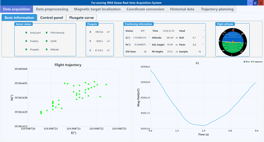
(1) The data collection section includes real-time data parsing, reception, display, and storage. In this section, several parameters can be configured, such as the display length of magnetic field curves, real-time mean value removal, real-time magnetic anomaly optimization filtering, magnetic data compensation and other algorithms, and the sampling rate.
(2) The data preprocessing section can process the saved data of this software, including the adaptive filtering, low-pass filtering, high pass filtering and band-pass filtering. Furthermore, it can perform data compensation processing for the filtered data.
(3) Real-time magnetic mapping section supports the magnetic mapping display of the selected area with one click.
(4) The coordinate transformation section can convert three expressions of latitude and longitude from each other.
(5) The historical data processing part can manage, preview, and replay the data saved by this software.
(6) The trajectory planning section can be used to generate trajectory planning files for DJI M400 drone.